19/02/2014
The great flood expert George Monbiot is very much in demand these days, with his latest effort in
The Guardian recounting, "How we ended up paying farmers to flood our homes", asserting that the government has "let the farming lobby rip up the rulebook on soil protection". And now, says Monbiot, "we are suffering the consequences".
Experience tells us to be cautious about anything claimed by Mr Monbiot and, if he is to be believed now, it is entirely because of changes in the rules in maize growing that places such as the Somerset Levels and parts of the Thames basin have become flooded.
In typical style, Mr Monbiot chooses as his first example which, to him, has the "force of a parable" the road from High Ham to Burrowbridge on the Somerset Levels. This, he tells us, skirts Lake Paterson (formerly known as the Somerset Levels), whence you can see field after field of harvested maize.
In some places, says Monbiot, "the crop lines run straight down the hill and into the water. When it rains, the water and soil flash off into the lake. Seldom are cause and effect so visible". And that, is as far as it goes - the direct evidence to support the case for the prosecution as far as the Levels go. Distant hills, partly wooded are in some instances used for maize growing. The run-off from those fields has caused the inundation of the Levels.
Before looking at his indirect evidence - and we'll do that in Part II - we can already perceive that Mr Monbiot is, at the very least, exaggerating. The route from High Ham to Burrowbridge that he describes is very much part of the Levels. As befits their name, they are actually quite level. Hills are only a distant backdrop. If he personally witnessed "water and soil flash off into the lake", it wasn't from this vantage point.
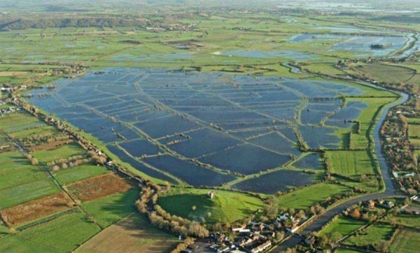
However, there is an important feature of this "lake" which Mr Monbiot so contemptuously refers to as Lake Paterson, one which he neglects to tell us. It might have an influence on its current status though.
The lake is in fact Southlake Moor (above). Would that Mr Monbiot knew it, this area did not get the bulk of its water from distant hills - not directly at any rate. It is designed to be flooded deliberately, from a specially constructed inlet connected to the River Sowy. This is part of a Defra-funded
£8 million scheme which is designed to turn the Moor
back into wetland.
Shown is the scene not from this winter but from 2009/10, when the Moor was first deliberately flooded. As you can see, the village of Burrowbridge - much in the news of late - is in the foreground, on the edge of the flooded area. The road on which Mr Monbiot says he travelled borders the left-hand edge of the flooded area, and the River Parrett is to the right-hand edge.
The original picture can be seen
here and the area is described as "the first wetland restoration scheme to be completed by the Parrett IDB [Internal Drainage Board]". It marks, we are told, "a significant change in the Board's activities towards more multi-functional and sustainable management of floodplain wetland systems".
In other words, the scheme marks the transition of a public body set up initially to drain part of the Levels to a body dedicated to its "sustainable" flooding. And, while no money could be found for dredging, it seems that no expense was spared by the last Labour government to turn this area into a lake. The picture below shows the new work, not dedicated to draining the land but to flooding it.

With £8 million spent on the scheme, where are the cuts about which there has been so much lamenting? This is a joint scheme between the Environment Agency, the Somerset IDB consortium and Natural England, which owns the land, together with the RSPB. There was money for designer floods, it seems, but not for dredging the rivers.
Another part of the scheme is a series of sluices, upgraded watercourses and culverts, which are designed to prevent Southlake overflowing, once its storage capacity of 1.2 million cubic metres has been reached. But, since these discharge into the River Parrett, which has not been upgraded, and has been allowed to silt up after decades in which there has been no dredging, it seems as if the scheme has gone badly wrong.
It cannot have helped that the Met Office medium-range forecast was for a dry winter, on the basis of which Southlake, as far as I can ascertain, seems to have been flooded in December, in what counts as "normal" in this topsy turvy land.
One supposes that, had it been known that the rains would not stop, or had not the scheme been in place at all, the Moor could have acted as a natural reservoir to soak up the excess waters. But, as a zone now earmarked for deliberate flooding, the capacity was no longer available to soak up the rain.
In the general scheme of things, therefore, the run-off from whatever maize fields Monbiot could have seen on the distant hills (mostly wooded) would have been the least of the problems confronting the people of the Levels. It is inconceivable that they could have made any significant contribution to the floods.
This, however, is only one aspect in which Mr Monbiot's story starts completely to unravel. Later today, I will look at the rest of his article and make some observation. But even at this stage, I can say that nothing he has on offer hangs together. Yet, for the gullible, not least Nick Cohen in the
Spectator, this is the man who knows.
It is utterly bizarre that so unreliable a source should be taken at face value. Rather than us paying farmers to flooding our homes, as Mr Monbiot asserts, all we have so far is the government cutting out the middleman and doing the job itself, with our tax money. And Part II is yet to come.